Goodridge Voting District, Pennington County, Minnesota
About
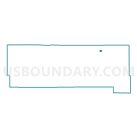
Outline

Summary
| Unique Area Identifier | 603561 |
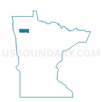
| Name | Goodridge Voting District |
| County | Pennington County |
| State | Minnesota |
| Area (square miles) | 0.19 |
| Land Area (square miles) | 0.19 |
| Water Area (square miles) | 0.00 |
| % of Land Area | 100.00 |
| % of Water Area | 0.00 |
| Latitude of the Internal Point | 48.14412050 |
| Longtitude of the Internal Point | -95.80393230 |
Maps

Graphs
Select a template below for downloading or customizing gragh for Goodridge Voting District, Pennington County, Minnesota